


Guide Rock Precinct, Webster County, Nebraska
About
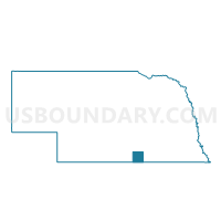
Outline

Summary
| Unique Area Identifier | 614026 |
| Name | Guide Rock Precinct |
| County | Webster County |
| State | Nebraska |
| Area (square miles) | 108.07 |
| Land Area (square miles) | 108.00 |
| Water Area (square miles) | 0.07 |
| % of Land Area | 99.94 |
| % of Water Area | 0.06 |
| Latitude of the Internal Point | 40.14085090 |
| Longtitude of the Internal Point | -98.33406550 |
Maps

Graphs
Select a template below for downloading or customizing gragh for Guide Rock Precinct, Webster County, Nebraska


Neighbors
Neighoring Voting District (by Name) Neighboring Voting District on the Map
- Beaver 1 Precinct, Nuckolls County, NE
- Blue Hill Precinct, Webster County, NE
- Red Cloud 1st Precinct, Webster County, NE
- Victor Precinct, Nuckolls County, NE
- Walnut Township Voting District, Jewell County, KS
Top 10 Neighboring County Subdivision (by Population) Neighboring County Subdivision on the Map
- District 2, Webster County, NE (737)
- District 1, Webster County, NE (702)
- Victor precinct, Nuckolls County, NE (582)
- Beaver precinct, Nuckolls County, NE (225)
- Walnut township, Jewell County, KS (54)
Top 10 Neighboring Place (by Population) Neighboring Place on the Map
Top 10 Neighboring Unified School District (by Population) Neighboring Unified School District on the Map
- South Central Nebraska School District, NE (3,474)
- Superior Public Schools, NE (2,985)
- Rock Hills Unified School District 107, KS (2,794)
- Blue Hill Public Schools, NE (1,618)
- Red Cloud Community Schools, NE (1,542)
Top 10 Neighboring State Legislative District Lower Chamber (by Population) Neighboring State Legislative District Lower Chamber on the Map
Top 10 Neighboring State Legislative District Upper Chamber (by Population) Neighboring State Legislative District Upper Chamber on the Map
Top 10 Neighboring 111th Congressional District (by Population) Neighboring 111th Congressional District on the Map
Top 10 Neighboring Census Tract (by Population) Neighboring Census Tract on the Map
- Census Tract 9600, Nuckolls County, NE (2,394)
- Census Tract 9650, Webster County, NE (1,974)
- Census Tract 9651, Webster County, NE (1,838)
- Census Tract 5761, Jewell County, KS (1,096)